Fruit Heights night lights from space
Night Light of Fruit Heights (Utah) from space (United States) Src. Average luminocity for 10x10km area is 37.3078% and for 50x50km: 16.3115%.
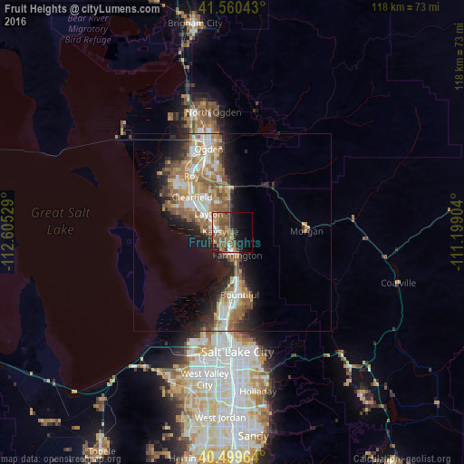
Analysis of Fruit Heights night lights 2016
Square area 10x10 km:
 3.57%
3.57%90-99
2.55%80-89
2.72%70-79
5.1%60-69
9.86%50-59
16.33%40-49
8.84%30-39
1.53%20-29
6.97%10-19
19.9%0-9
22.62%Square area 50x50 km:
2.4%90-99
2.68%80-89
1.54%70-79
2.55%60-69
3.51%50-59
3.63%40-49
1.94%30-39
1.78%20-29
3.96%10-19
7.09%0-9
68.92%Clear (daylight) street map image can be seen on geolist.org.
Map coordinates:
41° 33' 37.5" North, 112° 36' 19" West
41° 1' 55.8" North, 111° 54' 7.8" West
40° 29' 58.7" North, 111° 11' 56.5" West
Some cities around Fruit Heights sort by population:
• Layton
6.6 km =4.1 mi,  298°
298°
• Clearfield
13.6 km =8.5 mi,  310°
310°
• Kaysville
3.1 km =1.9 mi,  276°
276°
• Syracuse
15 km =9.3 mi, 295°
• Farmington
5.9 km =3.7 mi,  167°
167°
• Centerville
12.9 km =8 mi, 168°
• South Weber
11.4 km =7.1 mi,  348°
348°
• West Bountiful
15.4 km =9.6 mi,  179°
179°
5775035 (p: 6,072)
Sources (retrieved 2019-11-25):
» Earth at Night: Flat Maps 2012, 2016