Frostburg night lights from space
Night Light of Frostburg (Maryland) from space (United States) Src. Average luminocity for 10x10km area is 16.2143% and for 50x50km: 5.3155%.
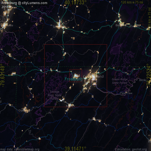
Analysis of Frostburg night lights 2016
Square area 10x10 km:
 2.44%
2.44%90-99
1.46%80-89
1.3%70-79
1.79%60-69
1.14%50-59
3.57%40-49
2.6%30-39
1.79%20-29
2.76%10-19
9.09%0-9
72.08%Square area 50x50 km:
0.52%90-99
0.43%80-89
0.9%70-79
0.5%60-69
0.58%50-59
1.01%40-49
0.95%30-39
0.98%20-29
1.47%10-19
3.62%0-9
89.04%Clear (daylight) street map image can be seen on geolist.org.
Map coordinates:
40° 11' 50.4" North, 79° 37' 53.4" West
39° 39' 29.3" North, 78° 55' 42.1" West
39° 6' 53" North, 78° 13' 30.9" West
Some cities around Frostburg sort by population:
• Cumberland
14.2 km =8.8 mi,  92°
92°
• Johnstown
74.3 km =46.2 mi,  0°
0°
• Uniontown
72.5 km =45 mi,  291°
291°
• Latrobe
83.1 km =51.6 mi,  332°
332°
• Cheat Lake
79.2 km =49.2 mi,  271°
271°
• Connellsville
69.2 km =43 mi,  305°
305°
• Somerset
41 km =25.5 mi,  341°
341°
• Keyser
24.5 km =15.2 mi,  189°
189°
4355756 (p: 8,667)
Sources (retrieved 2019-11-25):
» Earth at Night: Flat Maps 2012, 2016