Latrobe night lights from space
Night Light of Latrobe (Pennsylvania) from space (United States) Src. Average luminocity for 10x10km area is 37.8231% and for 50x50km: 14.1562%.
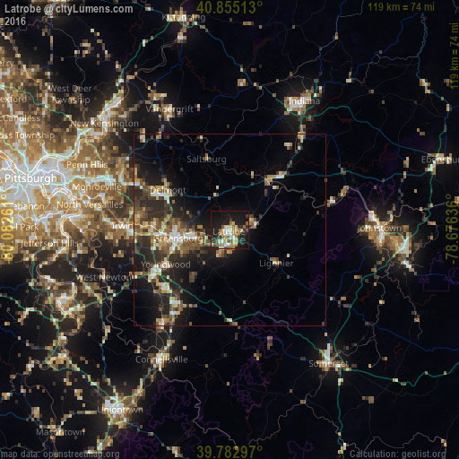
Analysis of Latrobe night lights 2016
Square area 10x10 km:
 4.08%
4.08%90-99
4.93%80-89
5.61%70-79
6.8%60-69
5.95%50-59
6.8%40-49
3.06%30-39
3.74%20-29
12.07%10-19
36.22%0-9
10.71%Square area 50x50 km:
1.15%90-99
1.64%80-89
1.94%70-79
1.76%60-69
1.9%50-59
2.42%40-49
2.57%30-39
3.28%20-29
5.77%10-19
9.18%0-9
68.38%Clear (daylight) street map image can be seen on geolist.org.
Map coordinates:
40° 51' 18.5" North, 80° 4' 57.4" West
40° 19' 16.2" North, 79° 22' 46.1" West
39° 46' 58.7" North, 78° 40' 34.9" West
Some cities around Latrobe sort by population:
• Monroeville
36.4 km =22.6 mi,  287°
287°
• Plum
37.1 km =23.1 mi,  302°
302°
• Murrysville
29.5 km =18.3 mi, 293°
• Greensburg
13.7 km =8.5 mi,  260°
260°
• North Versailles
37 km =23 mi,  280°
280°
• Jeannette
20 km =12.4 mi,  272°
272°
• White Oak
36.5 km =22.7 mi, 272°
• Vandergrift
35 km =21.7 mi,  333°
333°
5197227 (p: 8,081)
Sources (retrieved 2019-11-25):
» Earth at Night: Flat Maps 2012, 2016