Uniontown night lights from space
Night Light of Uniontown (Pennsylvania) from space (United States) Src. Average luminocity for 10x10km area is 52.9643% and for 50x50km: 12.615%.
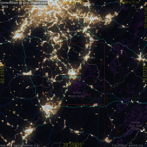
Analysis of Uniontown night lights 2016
Square area 10x10 km:
 9.01%
9.01%90-99
9.69%80-89
5.1%70-79
5.44%60-69
11.05%50-59
10.2%40-49
11.05%30-39
8.5%20-29
16.16%10-19
12.59%0-9
1.19%Square area 50x50 km:
0.67%90-99
1.07%80-89
1.36%70-79
1.21%60-69
1.88%50-59
2.18%40-49
2.45%30-39
2.62%20-29
4.37%10-19
13.58%0-9
68.6%Clear (daylight) street map image can be seen on geolist.org.
Map coordinates:
40° 26' 14.5" North, 80° 25' 10.4" West
39° 54' 0.3" North, 79° 42' 59.1" West
39° 21' 30.8" North, 79° 0' 47.9" West
Some cities around Uniontown sort by population:
• Morgantown
36.4 km =22.6 mi,  214°
214°
• Cheat Lake
27.9 km =17.3 mi,  204°
204°
• Maple Glen
25.6 km =15.9 mi,  300°
300°
• Connellsville
17 km =10.6 mi,  39°
39°
• Monessen
31.2 km =19.4 mi,  332°
332°
• Clairton
45.8 km =28.5 mi,  342°
342°
• California
23.7 km =14.7 mi,  320°
320°
• Brookhaven
35.9 km =22.3 mi, 206°
4561859 (p: 9,990)
Sources (retrieved 2019-11-25):
» Earth at Night: Flat Maps 2012, 2016