Somerset night lights from space
Night Light of Somerset (Pennsylvania) from space (United States) Src. Average luminocity for 10x10km area is 28.2313% and for 50x50km: 2.6047%.
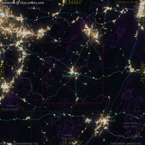
Analysis of Somerset night lights 2016
Square area 10x10 km:
 3.4%
3.4%90-99
4.93%80-89
2.89%70-79
1.53%60-69
3.57%50-59
5.78%40-49
6.12%30-39
4.42%20-29
3.91%10-19
31.12%0-9
32.31%Square area 50x50 km:
0.14%90-99
0.25%80-89
0.21%70-79
0.19%60-69
0.49%50-59
0.47%40-49
0.65%30-39
0.61%20-29
0.65%10-19
1.69%0-9
94.64%Clear (daylight) street map image can be seen on geolist.org.
Map coordinates:
40° 32' 41.4" North, 79° 46' 52.4" West
40° 0' 30.3" North, 79° 4' 41.1" West
39° 28' 3.8" North, 78° 22' 29.9" West
Some cities around Somerset sort by population:
• Cumberland
47.8 km =29.7 mi,  145°
145°
• Johnstown
37.8 km =23.5 mi,  20°
20°
• Greensburg
50.9 km =31.6 mi,  309°
309°
• Uniontown
55.7 km =34.6 mi,  257°
257°
• Jeannette
57.9 km =36 mi, 307°
• Frostburg
41 km =25.5 mi,  161°
161°
• Latrobe
43.2 km =26.8 mi,  323°
323°
• Connellsville
43.6 km =27.1 mi,  271°
271°
5212853 (p: 6,032)
Sources (retrieved 2019-11-25):
» Earth at Night: Flat Maps 2012, 2016