Freeport night lights from space
Night Light of Freeport (Texas) from space (United States) Src. Average luminocity for 10x10km area is 67.5556% and for 50x50km: 10.5674%.
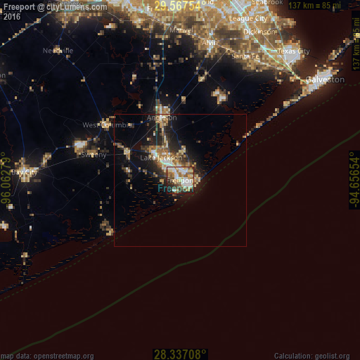
Analysis of Freeport night lights 2016
Square area 10x10 km:
 13.89%
90-99
16.87%80-89
12.5%70-79
8.33%60-69
7.14%50-59
11.71%40-49
9.52%30-39
5.95%20-29
9.52%10-19
4.56%0-9
0%Square area 50x50 km:
1.1%90-99
1.25%80-89
1.81%70-79
1.29%60-69
1.56%50-59
1.6%40-49
1.54%30-39
1.86%20-29
3.46%10-19
6.64%0-9
77.89%Clear (daylight) street map image can be seen on geolist.org.
Map coordinates:
29° 34' 3.1" North, 96° 3' 46" West
28° 57' 14.9" North, 95° 21' 34.8" West
28° 20' 13.5" North, 94° 39' 23.5" West
Some cities around Freeport sort by population:
• Lake Jackson
11.5 km =7.1 mi,  320°
320°
• Alvin
53.4 km =33.2 mi,  12°
12°
• Angleton
24.9 km =15.5 mi,  343°
343°
• Bay City
59.4 km =36.9 mi,  273°
273°
• Santa Fe
53.2 km =33.1 mi,  27°
27°
• Clute
8.7 km =5.4 mi,  334°
334°
• Manvel
56.6 km =35.2 mi,  0°
0°
• Hitchcock
55.1 km =34.2 mi,  37°
37°
4692355 (p: 12,154)
Sources (retrieved 2019-11-25):
» Earth at Night: Flat Maps 2012, 2016