Angleton night lights from space
Night Light of Angleton (Texas) from space (United States) Src. Average luminocity for 10x10km area is 39.254% and for 50x50km: 13.8956%.
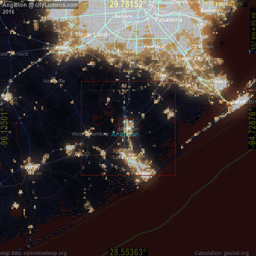
Analysis of Angleton night lights 2016
Square area 10x10 km:
 2.18%
2.18%90-99
4.56%80-89
6.35%70-79
5.56%60-69
9.72%50-59
8.13%40-49
5.16%30-39
6.75%20-29
7.74%10-19
41.67%0-9
2.18%Square area 50x50 km:
1.09%90-99
1.31%80-89
2.35%70-79
1.65%60-69
2.03%50-59
2.14%40-49
1.93%30-39
3.4%20-29
4.45%10-19
8.52%0-9
71.12%Clear (daylight) street map image can be seen on geolist.org.
Map coordinates:
29° 46' 53.5" North, 96° 8' 6" West
29° 10' 9.9" North, 95° 25' 54.8" West
28° 33' 13.1" North, 94° 43' 43.5" West
Some cities around Angleton sort by population:
• Lake Jackson
15.1 km =9.4 mi,  180°
180°
• Alvin
33.6 km =20.9 mi,  32°
32°
• Fresno
41.1 km =25.5 mi,  357°
357°
• Sienna Plantation
36 km =22.4 mi,  348°
348°
• Santa Fe
39.2 km =24.4 mi,  53°
53°
• Freeport
24.9 km =15.5 mi,  163°
163°
• Clute
16.4 km =10.2 mi,  168°
168°
• Manvel
33.4 km =20.8 mi,  12°
12°
4670866 (p: 19,429)
Sources (retrieved 2019-11-25):
» Earth at Night: Flat Maps 2012, 2016