Clute night lights from space
Night Light of Clute (Texas) from space (United States) Src. Average luminocity for 10x10km area is 68.2599% and for 50x50km: 12.6999%.
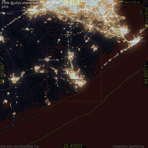
Analysis of Clute night lights 2016
Square area 10x10 km:
 12.7%
12.7%90-99
14.09%80-89
14.48%70-79
8.73%60-69
12.1%50-59
12.7%40-49
8.33%30-39
6.94%20-29
8.73%10-19
1.19%0-9
0%Square area 50x50 km:
1.22%90-99
1.42%80-89
2.16%70-79
1.56%60-69
1.88%50-59
1.96%40-49
1.82%30-39
2.36%20-29
3.88%10-19
8.09%0-9
73.65%Clear (daylight) street map image can be seen on geolist.org.
Map coordinates:
29° 38' 15.6" North, 96° 6' 7.1" West
29° 1' 28.9" North, 95° 23' 55.8" West
28° 24' 29" North, 94° 41' 44.6" West
Some cities around Clute sort by population:
• Lake Jackson
3.6 km =2.2 mi,  286°
286°
• Alvin
46.9 km =29.1 mi,  18°
18°
• Angleton
16.4 km =10.2 mi,  348°
348°
• Sienna Plantation
52.4 km =32.6 mi, 348°
• Santa Fe
48.5 km =30.1 mi,  35°
35°
• Freeport
8.7 km =5.4 mi,  154°
154°
• Manvel
48.9 km =30.4 mi,  4°
4°
• Hitchcock
51.7 km =32.1 mi,  45°
45°
4682163 (p: 11,444)
Sources (retrieved 2019-11-25):
» Earth at Night: Flat Maps 2012, 2016