Villa Hills night lights from space
Night Light of Villa Hills (Kentucky) from space (United States) Src. Average luminocity for 10x10km area is 86.7955% and for 50x50km: 49.288%.
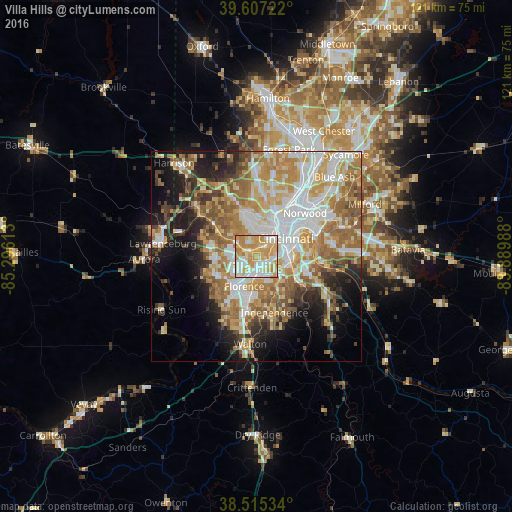
Analysis of Villa Hills night lights 2016
Square area 10x10 km:
 19.32%
90-99
26.46%80-89
19.81%70-79
28.08%60-69
6.33%50-59
0%40-49
0%30-39
0%20-29
0%10-19
0%0-9
0%Square area 50x50 km:
10.11%90-99
10.46%80-89
6.76%70-79
9.01%60-69
9.56%50-59
7.22%40-49
3.96%30-39
3.8%20-29
6.03%10-19
10.4%0-9
22.69%Clear (daylight) street map image can be seen on geolist.org.
Map coordinates:
39° 36' 26" North, 85° 17' 46.1" West
39° 3' 48.2" North, 84° 35' 34.8" West
38° 30' 55.2" North, 83° 53' 23.6" West
Some cities around Villa Hills sort by population:
• Covington
7.6 km =4.7 mi,  72°
72°
• Erlanger
5.2 km =3.2 mi,  187°
187°
• Edgewood
5.1 km =3.2 mi,  169°
169°
• Elsmere
5.7 km =3.5 mi, 190°
• Fort Mitchell
4 km =2.5 mi,  96°
96°
• Covedale
6.5 km =4 mi,  349°
349°
• Fort Wright
5.2 km =3.2 mi, 104°
• Delhi Hills
3.7 km =2.3 mi,  332°
332°
4312088 (p: 7,468)
Sources (retrieved 2019-11-25):
» Earth at Night: Flat Maps 2012, 2016