Erlanger night lights from space
Night Light of Erlanger (Kentucky) from space (United States) Src. Average luminocity for 10x10km area is 88.3782% and for 50x50km: 43.042%.
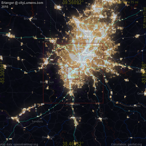
Analysis of Erlanger night lights 2016
Square area 10x10 km:
 30.52%
90-99
29.55%80-89
9.74%70-79
15.91%60-69
11.69%50-59
2.6%40-49
0%30-39
0%20-29
0%10-19
0%0-9
0%Square area 50x50 km:
8.72%90-99
8.86%80-89
5.86%70-79
7.85%60-69
8.27%50-59
6.61%40-49
3.48%30-39
3.5%20-29
5.32%10-19
9.48%0-9
32.04%Clear (daylight) street map image can be seen on geolist.org.
Map coordinates:
39° 33' 39.3" North, 85° 18' 14.1" West
39° 1' 0.2" North, 84° 36' 2.8" West
38° 28' 6" North, 83° 53' 51.6" West
Some cities around Erlanger sort by population:
• Florence
3 km =1.9 mi,  228°
228°
• Oakbrook
7.5 km =4.7 mi,  255°
255°
• Edgewood
1.6 km =1 mi,  82°
82°
• Elsmere
0.6 km =0.4 mi,  215°
215°
• Fort Mitchell
6.6 km =4.1 mi,  44°
44°
• Villa Hills
5.2 km =3.2 mi,  7°
7°
• Fort Wright
6.9 km =4.3 mi,  55°
55°
• Delhi Hills
8.5 km =5.3 mi,  353°
353°
4291255 (p: 18,797)
Sources (retrieved 2019-11-25):
» Earth at Night: Flat Maps 2012, 2016