Fort Valley night lights from space
Night Light of Fort Valley (Georgia) from space (United States) Src. Average luminocity for 10x10km area is 30.4773% and for 50x50km: 16.7749%.
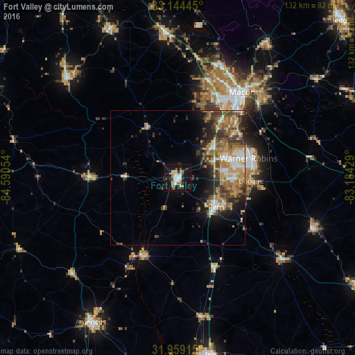
Analysis of Fort Valley night lights 2016
Square area 10x10 km:
 5.42%
5.42%90-99
5.07%80-89
2.45%70-79
4.9%60-69
4.72%50-59
2.62%40-49
1.75%30-39
4.55%20-29
3.15%10-19
38.64%0-9
26.75%Square area 50x50 km:
2.13%90-99
2.23%80-89
1.73%70-79
3.53%60-69
3.29%50-59
2.29%40-49
2.82%30-39
3.67%20-29
3.51%10-19
6.51%0-9
68.28%Clear (daylight) street map image can be seen on geolist.org.
Map coordinates:
33° 8' 40" North, 84° 35' 25.9" West
32° 33' 13.5" North, 83° 53' 14.7" West
31° 57' 32.9" North, 83° 11' 3.4" West
Some cities around Fort Valley sort by population:
• Macon
39.8 km =24.7 mi,  36°
36°
• Warner Robins
25.4 km =15.8 mi,  74°
74°
• Perry
18.1 km =11.2 mi,  126°
126°
• Thomaston
55.4 km =34.4 mi,  312°
312°
• Centerville
20.4 km =12.7 mi, 65°
• Barnesville
61.1 km =38 mi,  335°
335°
• Hawkinsville
49.2 km =30.6 mi, 127°
• Byron
16.3 km =10.1 mi,  47°
47°
4195869 (p: 8,597)
Sources (retrieved 2019-11-25):
» Earth at Night: Flat Maps 2012, 2016