Barnesville night lights from space
Night Light of Barnesville (Georgia) from space (United States) Src. Average luminocity for 10x10km area is 26.293% and for 50x50km: 13.2247%.
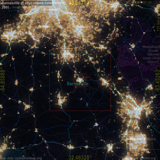
Analysis of Barnesville night lights 2016
Square area 10x10 km:
 2.2%
2.2%90-99
2.2%80-89
4.21%70-79
6.41%60-69
4.4%50-59
1.83%40-49
3.66%30-39
6.04%20-29
2.38%10-19
26.74%0-9
39.93%Square area 50x50 km:
0.91%90-99
1.12%80-89
1.33%70-79
2.42%60-69
1.88%50-59
1.85%40-49
2.3%30-39
3.81%20-29
3.3%10-19
12.13%0-9
68.96%Clear (daylight) street map image can be seen on geolist.org.
Map coordinates:
33° 38' 30.9" North, 84° 51' 32" West
33° 3' 16.5" North, 84° 9' 20.7" West
32° 27' 47.8" North, 83° 27' 9.5" West
Some cities around Barnesville sort by population:
• McDonough
43.7 km =27.2 mi,  1°
1°
• Griffin
23.6 km =14.7 mi,  334°
334°
• Fayetteville
51.9 km =32.2 mi, 327°
• Thomaston
24.4 km =15.2 mi,  220°
220°
• Irondale
51 km =31.7 mi,  338°
338°
• Hampton
38.8 km =24.1 mi, 342°
• Lovejoy
44.9 km =27.9 mi, 340°
• Locust Grove
32.7 km =20.3 mi,  7°
7°
4181110 (p: 6,625)
Sources (retrieved 2019-11-25):
» Earth at Night: Flat Maps 2012, 2016