Eloy night lights from space
Night Light of Eloy (Arizona) from space (United States) Src. Average luminocity for 10x10km area is 9.8829% and for 50x50km: 5.5465%.
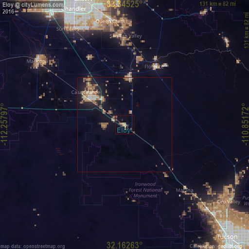
Analysis of Eloy night lights 2016
Square area 10x10 km:
 0%
0%90-99
0%80-89
1.4%70-79
2.27%60-69
0.87%50-59
4.2%40-49
0.7%30-39
1.57%20-29
1.22%10-19
2.45%0-9
85.31%Square area 50x50 km:
0.28%90-99
0.54%80-89
0.43%70-79
0.89%60-69
1.48%50-59
1.32%40-49
0.69%30-39
0.64%20-29
1.26%10-19
3.63%0-9
88.83%Clear (daylight) street map image can be seen on geolist.org.
Map coordinates:
33° 20' 42.9" North, 112° 15' 28.7" West
32° 45' 21.2" North, 111° 33' 17.4" West
32° 9' 45.5" North, 110° 51' 6.2" West
Some cities around Eloy sort by population:
• San Tan Valley
48.5 km =30.1 mi,  2°
2°
• Casa Grande
23.4 km =14.5 mi,  305°
305°
• Marana
47 km =29.2 mi,  138°
138°
• Florence
34.4 km =21.4 mi,  27°
27°
• Coolidge
24.9 km =15.5 mi,  8°
8°
• Arizona City
10.9 km =6.8 mi,  269°
269°
• Picture Rocks
54 km =33.6 mi,  147°
147°
• Avra Valley
41.9 km =26 mi, 147°
5294167 (p: 17,059)
Sources (retrieved 2019-11-25):
» Earth at Night: Flat Maps 2012, 2016