Avra Valley night lights from space
Night Light of Avra Valley (Arizona) from space (United States) Src. Average luminocity for 10x10km area is 1.5092% and for 50x50km: 4.2556%.
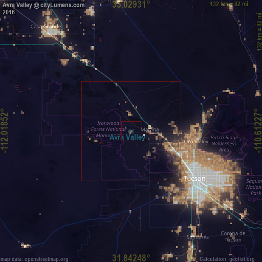
Analysis of Avra Valley night lights 2016
Square area 10x10 km:
 0%
0%90-99
0%80-89
0%70-79
0%60-69
0%50-59
0%40-49
0.73%30-39
1.28%20-29
1.65%10-19
0%0-9
96.34%Square area 50x50 km:
0.18%90-99
0.17%80-89
0.06%70-79
0.56%60-69
0.99%50-59
1.04%40-49
1.42%30-39
1.26%20-29
1.49%10-19
2.9%0-9
89.93%Clear (daylight) street map image can be seen on geolist.org.
Map coordinates:
33° 1' 45.5" North, 112° 1' 6.7" West
32° 26' 16.3" North, 111° 18' 55.4" West
31° 50' 32.9" North, 110° 36' 44.2" West
Some cities around Avra Valley sort by population:
• Casas Adobes
32.7 km =20.3 mi,  112°
112°
• Oro Valley
33.2 km =20.6 mi,  99°
99°
• Marana
8.4 km =5.2 mi,  90°
90°
• Flowing Wells
32.9 km =20.4 mi,  119°
119°
• Tucson Estates
34.9 km =21.7 mi,  142°
142°
• Picture Rocks
12.1 km =7.5 mi,  147°
147°
• Valencia West
38.9 km =24.2 mi, 150°
• Catalina
37.7 km =23.4 mi,  78°
78°
5552323 (p: 6,050)
Sources (retrieved 2019-11-25):
» Earth at Night: Flat Maps 2012, 2016