Marana night lights from space
Night Light of Marana (Arizona) from space (United States) Src. Average luminocity for 10x10km area is 9.7271% and for 50x50km: 10.4678%.
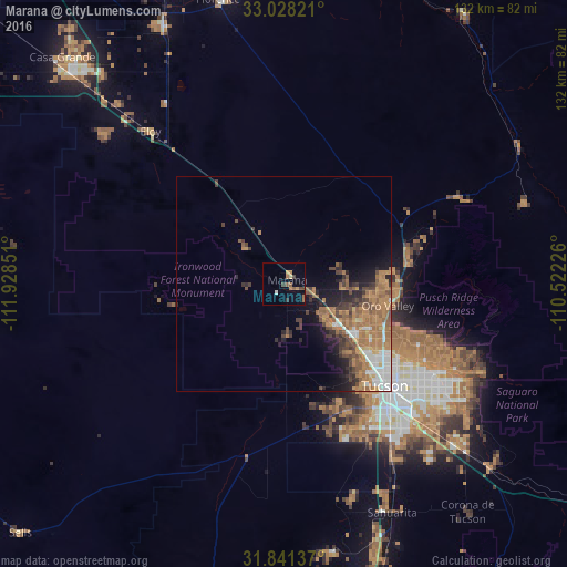

Analysis of Marana night lights 2016
Square area 10x10 km:
 0.18%
0.18%90-99
0.55%80-89
0.73%70-79
2.2%60-69
2.2%50-59
2.93%40-49
2.38%30-39
1.28%20-29
0%10-19
0.37%0-9
87.18%Square area 50x50 km:
1.38%90-99
1.07%80-89
0.47%70-79
1.89%60-69
3.78%50-59
2.04%40-49
1.8%30-39
1.5%20-29
1.79%10-19
3.7%0-9
80.59%Clear (daylight) street map image can be seen on geolist.org.
Map coordinates:
33° 1' 41.6" North, 111° 55' 42.6" West
32° 26' 12.3" North, 111° 13' 31.4" West
31° 50' 28.9" North, 110° 31' 20.1" West
Some cities around Marana sort by population:
• Casas Adobes
25 km =15.5 mi,  120°
120°
• Catalina Foothills
32.7 km =20.3 mi, 118°
• Oro Valley
24.8 km =15.4 mi,  101°
101°
• Flowing Wells
25.7 km =16 mi,  128°
128°
• Tucson Estates
30.4 km =18.9 mi,  155°
155°
• Picture Rocks
10.3 km =6.4 mi,  190°
190°
• Catalina
29.6 km =18.4 mi,  74°
74°
• Avra Valley
8.4 km =5.2 mi,  270°
270°
5303705 (p: 41,315)
Sources (retrieved 2019-11-25):
» Earth at Night: Flat Maps 2012, 2016