El Rio night lights from space
Night Light of El Rio (California) from space (United States) Src. Average luminocity for 10x10km area is 75.3498% and for 50x50km: 18.1524%.
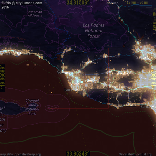
Analysis of El Rio night lights 2016
Square area 10x10 km:
 18.5%
18.5%90-99
15.38%80-89
8.42%70-79
14.1%60-69
19.23%50-59
11.9%40-49
8.61%30-39
3.85%20-29
0%10-19
0%0-9
0%Square area 50x50 km:
2.01%90-99
2.41%80-89
1.26%70-79
2.45%60-69
4.53%50-59
3.35%40-49
4.1%30-39
3.11%20-29
4.56%10-19
9.03%0-9
63.2%Clear (daylight) street map image can be seen on geolist.org.
Map coordinates:
34° 48' 54.2" North, 119° 52' 1.1" West
34° 14' 8.8" North, 119° 9' 49.8" West
33° 39' 8.9" North, 118° 27' 38.6" West
Some cities around El Rio sort by population:
• Oxnard
4.4 km =2.7 mi,  195°
195°
• Ventura
12.8 km =8 mi,  291°
291°
• Camarillo
11.8 km =7.3 mi,  100°
100°
• Moorpark
26.5 km =16.5 mi,  77°
77°
• Santa Paula
16.3 km =10.1 mi,  36°
36°
• Port Hueneme
10.2 km =6.3 mi, 196°
• Ojai
24.7 km =15.3 mi,  342°
342°
• Mira Monte
24.7 km =15.3 mi,  333°
333°
5345844 (p: 7,198)
Sources (retrieved 2019-11-25):
» Earth at Night: Flat Maps 2012, 2016