Collinsville night lights from space
Night Light of Collinsville (Virginia) from space (United States) Src. Average luminocity for 10x10km area is 50.0897% and for 50x50km: 7.2774%.
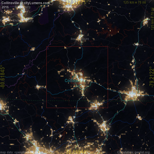
Analysis of Collinsville night lights 2016
Square area 10x10 km:
 6.23%
6.23%90-99
6.59%80-89
6.59%70-79
9.52%60-69
10.44%50-59
10.44%40-49
7.69%30-39
7.88%20-29
15.93%10-19
16.85%0-9
1.83%Square area 50x50 km:
0.44%90-99
0.54%80-89
0.94%70-79
1.05%60-69
1.04%50-59
1.44%40-49
1.44%30-39
1.93%20-29
2.26%10-19
5.31%0-9
83.61%Clear (daylight) street map image can be seen on geolist.org.
Map coordinates:
37° 16' 36.2" North, 80° 37' 6.4" West
36° 42' 54.5" North, 79° 54' 55.2" West
36° 8' 58" North, 79° 12' 43.9" West
Some cities around Collinsville sort by population:
• Danville
48.6 km =30.2 mi,  107°
107°
• Cave Spring
57.6 km =35.8 mi,  351°
351°
• Eden
28.5 km =17.7 mi,  152°
152°
• Reidsville
45.9 km =28.5 mi, 150°
• Martinsville
4.6 km =2.9 mi,  124°
124°
• Summerfield
56.3 km =35 mi,  179°
179°
• Oak Ridge
60.6 km =37.7 mi,  186°
186°
• Stokesdale
53.5 km =33.2 mi, 186°
4753635 (p: 7,335)
Sources (retrieved 2019-11-25):
» Earth at Night: Flat Maps 2012, 2016