Chesapeake Beach night lights from space
Night Light of Chesapeake Beach (Maryland) from space (United States) Src. Average luminocity for 10x10km area is 13.0527% and for 50x50km: 9.9123%.
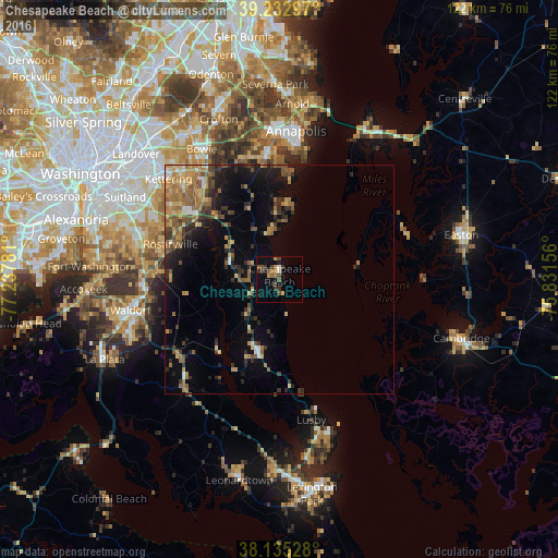
Analysis of Chesapeake Beach night lights 2016
Square area 10x10 km:
 0.51%
0.51%90-99
0.34%80-89
1.19%70-79
1.7%60-69
2.55%50-59
2.21%40-49
4.25%30-39
4.25%20-29
0.17%10-19
6.12%0-9
76.7%Square area 50x50 km:
0.48%90-99
0.51%80-89
1.39%70-79
1.63%60-69
2.24%50-59
2.02%40-49
1.51%30-39
2.11%20-29
2.32%10-19
5.37%0-9
80.41%Clear (daylight) street map image can be seen on geolist.org.
Map coordinates:
39° 13' 58.7" North, 77° 14' 16.1" West
38° 41' 10.4" North, 76° 32' 4.8" West
38° 8' 7" North, 75° 49' 53.6" West
Some cities around Chesapeake Beach sort by population:
• Greater Upper Marlboro
24.6 km =15.3 mi,  311°
311°
• Rosaryville
25.1 km =15.6 mi,  288°
288°
• Brock Hall
26.8 km =16.7 mi, 312°
• Marlboro Village
25.9 km =16.1 mi, 308°
• Marlton
24.2 km =15 mi, 293°
• Mayo
22.5 km =14 mi,  5°
5°
• Brandywine
27.2 km =16.9 mi,  272°
272°
• Shady Side
17.4 km =10.8 mi, 6°
4351184 (p: 5,873)
Sources (retrieved 2019-11-25):
» Earth at Night: Flat Maps 2012, 2016