Stevensville night lights from space
Night Light of Stevensville (Maryland) from space (United States) Src. Average luminocity for 10x10km area is 20.0633% and for 50x50km: 15.9492%.
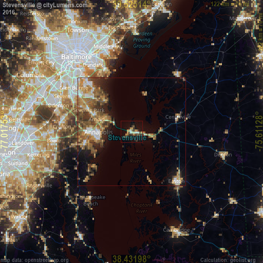
Analysis of Stevensville night lights 2016
Square area 10x10 km:
 2.27%
2.27%90-99
1.3%80-89
3.41%70-79
4.06%60-69
0.65%50-59
1.79%40-49
2.76%30-39
6.82%20-29
1.95%10-19
19.16%0-9
55.84%Square area 50x50 km:
1.66%90-99
1.83%80-89
2.29%70-79
2.55%60-69
2.89%50-59
3.74%40-49
3.02%30-39
3.02%20-29
2.64%10-19
5.8%0-9
70.56%Clear (daylight) street map image can be seen on geolist.org.
Map coordinates:
39° 31' 30.5" North, 77° 1' 3.1" West
38° 58' 50.4" North, 76° 18' 51.8" West
38° 25' 55.1" North, 75° 36' 40.6" West
Some cities around Stevensville sort by population:
• Annapolis
15.3 km =9.5 mi,  269°
269°
• Arnold
17.2 km =10.7 mi,  289°
289°
• Lake Shore
20.4 km =12.7 mi,  313°
313°
• Parole
18.7 km =11.6 mi, 269°
• Edgewater
20.5 km =12.7 mi,  262°
262°
• Cape Saint Claire
13.2 km =8.2 mi,  301°
301°
• Mayo
20 km =12.4 mi,  238°
238°
• Robinwood
17.6 km =10.9 mi, 260°
4370366 (p: 6,803)
Sources (retrieved 2019-11-25):
» Earth at Night: Flat Maps 2012, 2016