East San Gabriel night lights from space
Night Light of East San Gabriel (California) from space (United States) Src. Average luminocity for 10x10km area is 94.1667% and for 50x50km: 70.8555%.
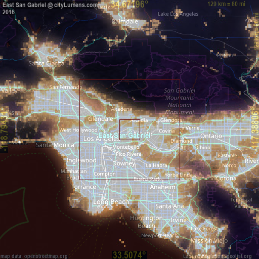
Analysis of East San Gabriel night lights 2016
Square area 10x10 km:
 36.81%
90-99
33.88%80-89
24.18%70-79
5.13%60-69
0%50-59
0%40-49
0%30-39
0%20-29
0%10-19
0%0-9
0%Square area 50x50 km:
36.37%90-99
16.51%80-89
5.97%70-79
7.59%60-69
5.88%50-59
2.87%40-49
1.47%30-39
1.32%20-29
1.93%10-19
3.88%0-9
16.21%Clear (daylight) street map image can be seen on geolist.org.
Map coordinates:
34° 40' 19.1" North, 118° 47' 39.5" West
34° 5' 30" North, 118° 5' 28.2" West
33° 30' 26.6" North, 117° 23' 17" West
Some cities around East San Gabriel sort by population:
• Alhambra
3.3 km =2.1 mi,  276°
276°
• Monterey Park
4.4 km =2.7 mi,  221°
221°
• Rosemead
2.1 km =1.3 mi,  126°
126°
• San Gabriel
1.4 km =0.9 mi,  290°
290°
• Temple City
3.5 km =2.2 mi,  60°
60°
• South El Monte
6 km =3.7 mi,  137°
137°
• San Marino
3.6 km =2.2 mi,  336°
336°
• South San Gabriel
4.7 km =2.9 mi,  183°
183°
5345071 (p: 14,874)
Sources (retrieved 2019-11-25):
» Earth at Night: Flat Maps 2012, 2016