East Meadow night lights from space
Night Light of East Meadow (New York) from space (United States) Src. Average luminocity for 10x10km area is 99.4821% and for 50x50km: 56.6834%.
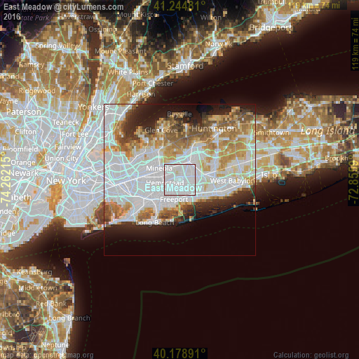
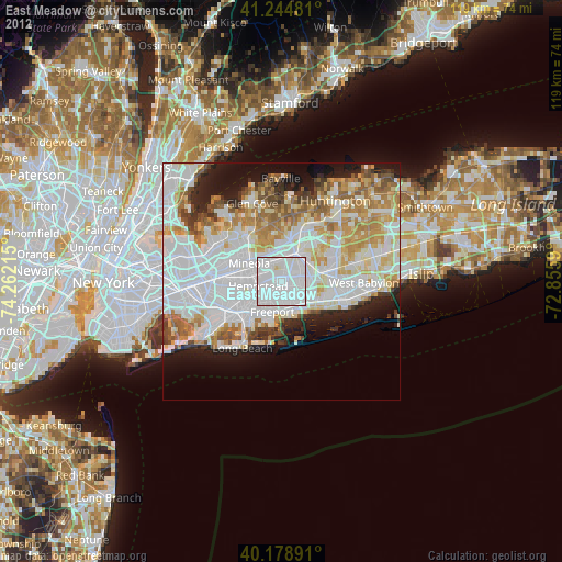
Analysis of East Meadow night lights 2016
Square area 10x10 km:
 74.03%
90-99
25.32%80-89
0.65%70-79
0%60-69
0%50-59
0%40-49
0%30-39
0%20-29
0%10-19
0%0-9
0%Square area 50x50 km:
23.38%90-99
12.88%80-89
5.28%70-79
6.27%60-69
5.97%50-59
4.74%40-49
3.25%30-39
2.86%20-29
5.72%10-19
7.69%0-9
21.98%Clear (daylight) street map image can be seen on geolist.org.
Map coordinates:
41° 14' 41.3" North, 74° 15' 43.7" West
40° 42' 50.4" North, 73° 33' 32.5" West
40° 10' 44.1" North, 72° 51' 21.2" West
Some cities around East Meadow sort by population:
• Hempstead
5.1 km =3.2 mi,  260°
260°
• Levittown
4 km =2.5 mi,  70°
70°
• Uniondale
3.2 km =2 mi,  242°
242°
• North Bellmore
3.3 km =2.1 mi,  139°
139°
• Roosevelt
4.7 km =2.9 mi,  212°
212°
• North Merrick
2.6 km =1.6 mi,  187°
187°
• Salisbury
3.5 km =2.2 mi,  358°
358°
• North Wantagh
4.9 km =3 mi,  117°
117°
5115960 (p: 38,132)
Sources (retrieved 2019-11-25):
» Earth at Night: Flat Maps 2012, 2016