Donna night lights from space
Night Light of Donna (Texas) from space (United States) Src. Average luminocity for 10x10km area is 71.494% and for 50x50km: 47.8199%.
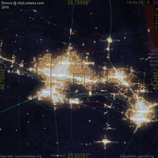
Analysis of Donna night lights 2016
Square area 10x10 km:
 9.92%
9.92%90-99
14.68%80-89
10.32%70-79
11.11%60-69
31.75%50-59
10.91%40-49
5.36%30-39
1.98%20-29
3.97%10-19
0%0-9
0%Square area 50x50 km:
8.93%90-99
7.56%80-89
8.3%70-79
7.62%60-69
10.15%50-59
7.64%40-49
5.31%30-39
5.33%20-29
7.5%10-19
11.45%0-9
20.2%Clear (daylight) street map image can be seen on geolist.org.
Map coordinates:
26° 47' 58.8" North, 98° 45' 18.3" West
26° 10' 13.3" North, 98° 3' 7" West
25° 32' 15.4" North, 97° 20' 55.8" West
Some cities around Donna sort by population:
• Pharr
13.4 km =8.3 mi,  281°
281°
• Weslaco
6.2 km =3.9 mi,  101°
101°
• San Juan
10.5 km =6.5 mi, 281°
• Alamo
7.2 km =4.5 mi, 281°
• Murillo Colonia
11.4 km =7.1 mi,  327°
327°
• Mila Doce
11.2 km =7 mi,  56°
56°
• Progreso
12.8 km =8 mi,  132°
132°
• Nurillo
12.8 km =8 mi, 327°
4686593 (p: 16,523)
Sources (retrieved 2019-11-25):
» Earth at Night: Flat Maps 2012, 2016