Progreso night lights from space
Night Light of Progreso (Texas) from space (United States) Src. Average luminocity for 10x10km area is 40.2421% and for 50x50km: 34.6977%.
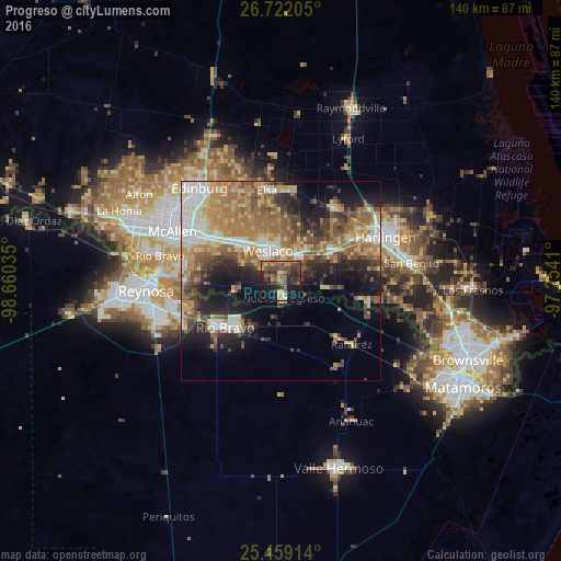
Analysis of Progreso night lights 2016
Square area 10x10 km:
 0.4%
0.4%90-99
1.98%80-89
7.34%70-79
7.94%60-69
5.75%50-59
9.92%40-49
13.89%30-39
11.31%20-29
12.7%10-19
24.21%0-9
4.56%Square area 50x50 km:
4.37%90-99
4.56%80-89
6.23%70-79
4.9%60-69
8.39%50-59
6.57%40-49
5.09%30-39
4.84%20-29
6.74%10-19
11.55%0-9
36.76%Clear (daylight) street map image can be seen on geolist.org.
Map coordinates:
26° 43' 19.4" North, 98° 39' 37.3" West
26° 5' 32.3" North, 97° 57' 26" West
25° 27' 32.9" North, 97° 15' 14.8" West
Some cities around Progreso sort by population:
• Ciudad Río Bravo, MX
18 km =11.2 mi,  229°
229°
• Weslaco
8.2 km =5.1 mi,  335°
335°
• Alamo
19.4 km =12.1 mi,  301°
301°
• Mercedes
7.7 km =4.8 mi,  34°
34°
• Donna
12.8 km =8 mi,  312°
312°
• Nuevo Progreso, MX
4.1 km =2.5 mi,  173°
173°
• La Feria
15.2 km =9.4 mi,  60°
60°
• Mila Doce
14.9 km =9.3 mi,  359°
359°
4720789 (p: 5,922)
Sources (retrieved 2019-11-25):
» Earth at Night: Flat Maps 2012, 2016