Mila Doce night lights from space
Night Light of Mila Doce (Texas) from space (United States) Src. Average luminocity for 10x10km area is 55.8452% and for 50x50km: 37.5529%.
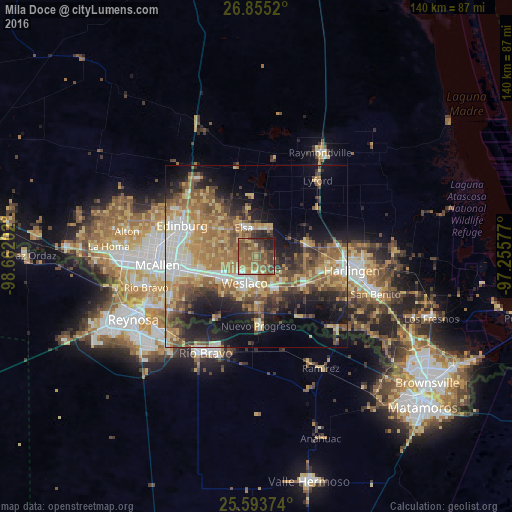
Analysis of Mila Doce night lights 2016
Square area 10x10 km:
 0.2%
0.2%90-99
2.58%80-89
10.71%70-79
6.15%60-69
22.22%50-59
28.57%40-49
10.32%30-39
10.32%20-29
5.36%10-19
3.57%0-9
0%Square area 50x50 km:
4.33%90-99
4.5%80-89
7.01%70-79
5.43%60-69
9.46%50-59
7.91%40-49
5.6%30-39
4.86%20-29
7.12%10-19
12.45%0-9
31.32%Clear (daylight) street map image can be seen on geolist.org.
Map coordinates:
26° 51' 18.7" North, 98° 39' 43.3" West
26° 13' 34.2" North, 97° 57' 32" West
25° 35' 37.5" North, 97° 15' 20.8" West
Some cities around Mila Doce sort by population:
• Weslaco
8.1 km =5 mi,  203°
203°
• Mercedes
9.6 km =6 mi,  151°
151°
• Donna
11.2 km =7 mi,  236°
236°
• Murillo Colonia
15.8 km =9.8 mi,  282°
282°
• La Feria
15.4 km =9.6 mi,  119°
119°
• Elsa
8.2 km =5.1 mi,  335°
335°
• Progreso
14.9 km =9.3 mi,  179°
179°
• Nurillo
16.8 km =10.4 mi,  285°
285°
4711253 (p: 6,222)
Sources (retrieved 2019-11-25):
» Earth at Night: Flat Maps 2012, 2016