Murillo Colonia night lights from space
Night Light of Murillo Colonia (Texas) from space (United States) Src. Average luminocity for 10x10km area is 76.9345% and for 50x50km: 47.8449%.
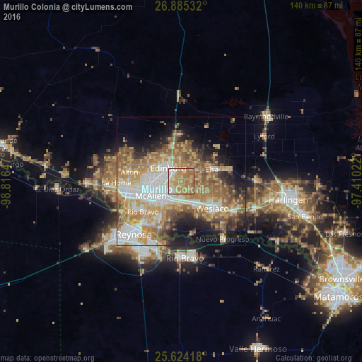
Analysis of Murillo Colonia night lights 2016
Square area 10x10 km:
 9.52%
9.52%90-99
10.71%80-89
18.45%70-79
22.02%60-69
37.5%50-59
1.79%40-49
0%30-39
0%20-29
0%10-19
0%0-9
0%Square area 50x50 km:
9.53%90-99
7.72%80-89
8.07%70-79
8.6%60-69
10.6%50-59
7.91%40-49
4.59%30-39
3.73%20-29
5.24%10-19
9.56%0-9
24.44%Clear (daylight) street map image can be seen on geolist.org.
Map coordinates:
26° 53' 7.2" North, 98° 48' 59.3" West
26° 15' 23.3" North, 98° 6' 48" West
25° 37' 27" North, 97° 24' 36.8" West
Some cities around Murillo Colonia sort by population:
• McAllen
13 km =8.1 mi,  243°
243°
• Edinburg
7.1 km =4.4 mi,  315°
315°
• Pharr
9.8 km =6.1 mi,  225°
225°
• San Juan
8.6 km =5.3 mi,  209°
209°
• Alamo
8.1 km =5 mi,  186°
186°
• Donna
11.4 km =7.1 mi,  147°
147°
• Elsa
12.7 km =7.9 mi,  71°
71°
• Nurillo
1.4 km =0.9 mi,  325°
325°
4713506 (p: 7,344)
Sources (retrieved 2019-11-25):
» Earth at Night: Flat Maps 2012, 2016