Dayton night lights from space
Night Light of Dayton (Texas) from space (United States) Src. Average luminocity for 10x10km area is 30.7292% and for 50x50km: 20.3243%.
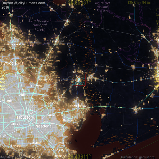
Analysis of Dayton night lights 2016
Square area 10x10 km:
 2.08%
2.08%90-99
3.41%80-89
5.11%70-79
5.11%60-69
2.08%50-59
3.98%40-49
2.46%30-39
7.77%20-29
7.95%10-19
55.49%0-9
4.55%Square area 50x50 km:
1.14%90-99
1.08%80-89
3.23%70-79
2.75%60-69
4.23%50-59
5%40-49
5.23%30-39
5.09%20-29
3.91%10-19
12.59%0-9
55.75%Clear (daylight) street map image can be seen on geolist.org.
Map coordinates:
30° 39' 12.1" North, 95° 35' 18" West
30° 2' 47.8" North, 94° 53' 6.7" West
29° 26' 10" North, 94° 10' 55.5" West
Some cities around Dayton sort by population:
• Baytown
35.7 km =22.2 mi,  194°
194°
• Atascocita
28.6 km =17.8 mi,  259°
259°
• Channelview
37.3 km =23.2 mi,  216°
216°
• Humble
36.7 km =22.8 mi, 261°
• Liberty
8.7 km =5.4 mi,  81°
81°
• Cleveland
38 km =23.6 mi,  329°
329°
• Highlands
30.2 km =18.8 mi,  213°
213°
• Mont Belvieu
22.1 km =13.7 mi,  181°
181°
4685449 (p: 7,575)
Sources (retrieved 2019-11-25):
» Earth at Night: Flat Maps 2012, 2016