Mont Belvieu night lights from space
Night Light of Mont Belvieu (Texas) from space (United States) Src. Average luminocity for 10x10km area is 77.744% and for 50x50km: 36.8482%.
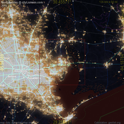
Analysis of Mont Belvieu night lights 2016
Square area 10x10 km:
 18.06%
90-99
14.68%80-89
13.29%70-79
16.67%60-69
21.23%50-59
10.71%40-49
2.98%30-39
0.79%20-29
1.59%10-19
0%0-9
0%Square area 50x50 km:
7.04%90-99
5.42%80-89
5.71%70-79
5.41%60-69
7.71%50-59
6.44%40-49
5.33%30-39
4.78%20-29
3.67%10-19
9.91%0-9
38.58%Clear (daylight) street map image can be seen on geolist.org.
Map coordinates:
30° 27' 20.6" North, 95° 35' 38" West
29° 50' 51.8" North, 94° 53' 26.7" West
29° 14' 9.6" North, 94° 11' 15.5" West
Some cities around Mont Belvieu sort by population:
• Baytown
15 km =9.3 mi,  213°
213°
• Channelview
23 km =14.3 mi,  249°
249°
• La Porte
23.7 km =14.7 mi, 211°
• Deer Park
27.5 km =17.1 mi,  234°
234°
• Cloverleaf
28.2 km =17.5 mi, 254°
• Liberty
25.1 km =15.6 mi,  21°
21°
• Dayton
22.1 km =13.7 mi,  1°
1°
• Highlands
16.3 km =10.1 mi,  258°
258°
4711967 (p: 5,193)
Sources (retrieved 2019-11-25):
» Earth at Night: Flat Maps 2012, 2016