Cumming night lights from space
Night Light of Cumming (Georgia) from space (United States) Src. Average luminocity for 10x10km area is 72.9176% and for 50x50km: 54.2765%.
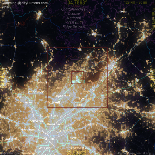
Analysis of Cumming night lights 2016
Square area 10x10 km:
 11.9%
11.9%90-99
13.92%80-89
9.16%70-79
13.92%60-69
27.47%50-59
15.57%40-49
4.03%30-39
4.03%20-29
0%10-19
0%0-9
0%Square area 50x50 km:
7.17%90-99
8.67%80-89
11.17%70-79
14.6%60-69
11.18%50-59
6.23%40-49
5.49%30-39
6%20-29
7.5%10-19
7.35%0-9
14.64%Clear (daylight) street map image can be seen on geolist.org.
Map coordinates:
34° 47' 12.5" North, 84° 50' 36" West
34° 12' 26.4" North, 84° 8' 24.7" West
33° 37' 25.8" North, 83° 26' 13.5" West
Some cities around Cumming sort by population:
• Johns Creek
20.6 km =12.8 mi,  195°
195°
• Alpharetta
20.4 km =12.7 mi,  223°
223°
• Milton
17 km =10.6 mi,  240°
240°
• Duluth
22.7 km =14.1 mi,  181°
181°
• Sugar Hill
14.9 km =9.3 mi,  138°
138°
• Suwanee
18.5 km =11.5 mi,  159°
159°
• Buford
15.8 km =9.8 mi,  127°
127°
• Flowery Branch
19.9 km =12.4 mi,  97°
97°
4190396 (p: 5,718)
Sources (retrieved 2019-11-25):
» Earth at Night: Flat Maps 2012, 2016