Flowery Branch night lights from space
Night Light of Flowery Branch (Georgia) from space (United States) Src. Average luminocity for 10x10km area is 66.3681% and for 50x50km: 52.9385%.
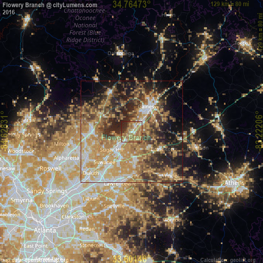
Analysis of Flowery Branch night lights 2016
Square area 10x10 km:
 5.31%
5.31%90-99
7.14%80-89
16.48%70-79
17.22%60-69
27.11%50-59
8.79%40-49
3.11%30-39
2.93%20-29
11.36%10-19
0.55%0-9
0%Square area 50x50 km:
6.58%90-99
7.1%80-89
9.73%70-79
13.49%60-69
10.59%50-59
6.99%40-49
7.75%30-39
8.57%20-29
9.89%10-19
10.4%0-9
8.9%Clear (daylight) street map image can be seen on geolist.org.
Map coordinates:
34° 45' 53" North, 84° 37' 41.9" West
34° 11' 6.4" North, 83° 55' 30.6" West
33° 36' 5.3" North, 83° 13' 19.4" West
Some cities around Flowery Branch sort by population:
• Gainesville
15.6 km =9.7 mi,  36°
36°
• Sugar Hill
13.3 km =8.3 mi,  228°
228°
• Suwanee
20 km =12.4 mi,  222°
222°
• Buford
10.2 km =6.3 mi, 225°
• Braselton
17.2 km =10.7 mi,  119°
119°
• Auburn
21.1 km =13.1 mi,  154°
154°
• Cumming
19.9 km =12.4 mi,  277°
277°
• Dacula
22 km =13.7 mi,  173°
173°
4195544 (p: 6,683)
Sources (retrieved 2019-11-25):
» Earth at Night: Flat Maps 2012, 2016