Cumberland night lights from space
Night Light of Cumberland (Indiana) from space (United States) Src. Average luminocity for 10x10km area is 65.5068% and for 50x50km: 48.5966%.
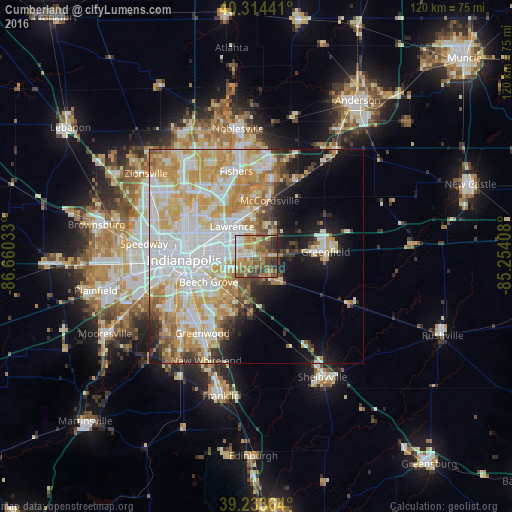
Analysis of Cumberland night lights 2016
Square area 10x10 km:
 8.84%
8.84%90-99
8.67%80-89
10.54%70-79
13.1%60-69
16.84%50-59
18.37%40-49
11.9%30-39
7.48%20-29
4.25%10-19
0%0-9
0%Square area 50x50 km:
13.26%90-99
11.86%80-89
7.38%70-79
9.41%60-69
5.49%50-59
3.52%40-49
3.03%30-39
2.88%20-29
3.78%10-19
8.68%0-9
30.71%Clear (daylight) street map image can be seen on geolist.org.
Map coordinates:
40° 18' 51.9" North, 86° 39' 37.2" West
39° 46' 34.1" North, 85° 57' 25.9" West
39° 14' 1.1" North, 85° 15' 14.7" West
Some cities around Cumberland sort by population:
• Indianapolis
17.2 km =10.7 mi,  267°
267°
• Fishers
20.5 km =12.7 mi,  346°
346°
• Greenwood
22.1 km =13.7 mi,  215°
215°
• Lawrence
9.1 km =5.7 mi,  320°
320°
• Greenfield
16.1 km =10 mi,  86°
86°
• Broad Ripple
18.7 km =11.6 mi,  302°
302°
• Beech Grove
12.8 km =8 mi,  242°
242°
• McCordsville
15 km =9.3 mi,  11°
11°
4256384 (p: 5,467)
Sources (retrieved 2019-11-25):
» Earth at Night: Flat Maps 2012, 2016