Cullman night lights from space
Night Light of Cullman (Alabama) from space (United States) Src. Average luminocity for 10x10km area is 63.6007% and for 50x50km: 7.2523%.
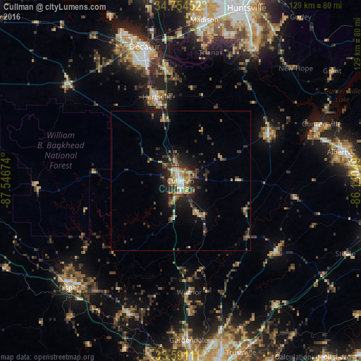
Analysis of Cullman night lights 2016
Square area 10x10 km:
 11.36%
90-99
8.79%80-89
16.67%70-79
10.44%60-69
11.36%50-59
8.06%40-49
7.88%30-39
9.89%20-29
13.19%10-19
2.38%0-9
0%Square area 50x50 km:
0.55%90-99
0.47%80-89
1.27%70-79
0.89%60-69
1.08%50-59
0.85%40-49
1.19%30-39
2.37%20-29
2.37%10-19
4.62%0-9
84.34%Clear (daylight) street map image can be seen on geolist.org.
Map coordinates:
34° 45' 16.3" North, 87° 32' 48.3" West
34° 10' 29.4" North, 86° 50' 37" West
33° 35' 28" North, 86° 8' 25.8" West
Some cities around Cullman sort by population:
• Decatur
49.6 km =30.8 mi,  345°
345°
• Dixiana
51.5 km =32 mi,  159°
159°
• Hartselle
31 km =19.3 mi,  344°
344°
• Jasper
55.3 km =34.4 mi,  226°
226°
• Guntersville
54.4 km =33.8 mi,  67°
67°
• Arab
35.7 km =22.2 mi,  63°
63°
• Oneonta
42.5 km =26.4 mi,  126°
126°
• Danville
34.8 km =21.6 mi,  319°
319°
4057835 (p: 15,350)
Sources (retrieved 2019-11-25):
» Earth at Night: Flat Maps 2012, 2016