Arab night lights from space
Night Light of Arab (Alabama) from space (United States) Src. Average luminocity for 10x10km area is 26.8407% and for 50x50km: 6.4389%.
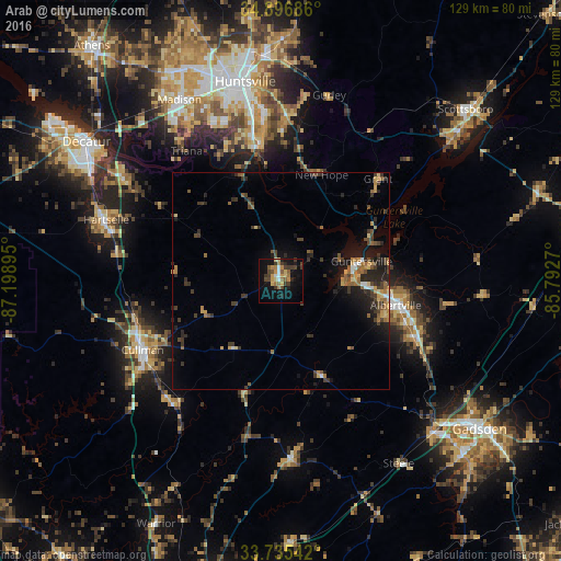
Analysis of Arab night lights 2016
Square area 10x10 km:
 1.65%
1.65%90-99
2.01%80-89
4.95%70-79
4.4%60-69
5.31%50-59
3.11%40-49
4.95%30-39
7.69%20-29
2.56%10-19
23.63%0-9
39.74%Square area 50x50 km:
0.27%90-99
0.3%80-89
0.86%70-79
0.8%60-69
1.25%50-59
0.92%40-49
1.19%30-39
2.12%20-29
1.93%10-19
4.45%0-9
85.91%Clear (daylight) street map image can be seen on geolist.org.
Map coordinates:
34° 53' 48.7" North, 87° 11' 56.2" West
34° 19' 5.3" North, 86° 29' 45" West
33° 44' 7.5" North, 85° 47' 33.7" West
Some cities around Arab sort by population:
• Huntsville
46.6 km =29 mi,  349°
349°
• Madison
48.3 km =30 mi,  331°
331°
• Albertville
27 km =16.8 mi,  101°
101°
• Cullman
35.7 km =22.2 mi,  243°
243°
• Hartselle
42.7 km =26.5 mi,  289°
289°
• Boaz
33 km =20.5 mi,  113°
113°
• Guntersville
19 km =11.8 mi,  76°
76°
• Oneonta
41.2 km =25.6 mi,  177°
177°
4830455 (p: 8,295)
Sources (retrieved 2019-11-25):
» Earth at Night: Flat Maps 2012, 2016