Crozet night lights from space
Night Light of Crozet (Virginia) from space (United States) Src. Average luminocity for 10x10km area is 8.1883% and for 50x50km: 6.4773%.
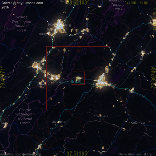
Analysis of Crozet night lights 2016
Square area 10x10 km:
 0%
0%90-99
0.65%80-89
0.32%70-79
2.27%60-69
1.3%50-59
2.11%40-49
1.95%30-39
1.79%20-29
2.27%10-19
1.3%0-9
86.04%Square area 50x50 km:
0.64%90-99
0.72%80-89
0.83%70-79
1.14%60-69
0.91%50-59
0.9%40-49
0.64%30-39
1.15%20-29
1.8%10-19
5.73%0-9
85.54%Clear (daylight) street map image can be seen on geolist.org.
Map coordinates:
38° 37' 15.7" North, 79° 24' 13.4" West
38° 4' 10.5" North, 78° 42' 2.1" West
37° 30' 50.2" North, 77° 59' 50.9" West
Some cities around Crozet sort by population:
• Charlottesville
20.1 km =12.5 mi,  102°
102°
• Staunton
33.8 km =21 mi,  285°
285°
• Waynesboro
16.5 km =10.3 mi,  269°
269°
• Lake Monticello
36 km =22.4 mi,  116°
116°
• Stuarts Draft
29.5 km =18.3 mi,  261°
261°
• Hollymead
23.3 km =14.5 mi,  76°
76°
• Fishersville
23.7 km =14.7 mi,  277°
277°
• Bridgewater
42.3 km =26.3 mi,  325°
325°
4754901 (p: 5,565)
Sources (retrieved 2019-11-25):
» Earth at Night: Flat Maps 2012, 2016