Lake Monticello night lights from space
Night Light of Lake Monticello (Virginia) from space (United States) Src. Average luminocity for 10x10km area is 2.2516% and for 50x50km: 4.849%.
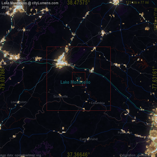
Analysis of Lake Monticello night lights 2016
Square area 10x10 km:
 0%
0%90-99
0%80-89
0.65%70-79
0.65%60-69
0%50-59
0%40-49
0.97%30-39
0.65%20-29
0%10-19
1.3%0-9
95.78%Square area 50x50 km:
0.57%90-99
0.58%80-89
0.7%70-79
0.87%60-69
0.62%50-59
0.5%40-49
0.58%30-39
0.87%20-29
1.49%10-19
3.24%0-9
89.99%Clear (daylight) street map image can be seen on geolist.org.
Map coordinates:
38° 28' 32.7" North, 79° 2' 16.3" West
37° 55' 23.5" North, 78° 20' 5" West
37° 21' 59.3" North, 77° 37' 53.8" West
Some cities around Lake Monticello sort by population:
• Charlottesville
17.1 km =10.6 mi,  313°
313°
• Waynesboro
51.2 km =31.8 mi,  288°
288°
• Culpeper
67.9 km =42.2 mi,  25°
25°
• Wyndham
68.2 km =42.4 mi,  111°
111°
• Stuarts Draft
62.4 km =38.8 mi,  280°
280°
• Hollymead
23.5 km =14.6 mi,  336°
336°
• Fishersville
58.9 km =36.6 mi, 289°
• Crozet
36 km =22.4 mi,  296°
296°
4768313 (p: 9,920)
Sources (retrieved 2019-11-25):
» Earth at Night: Flat Maps 2012, 2016