Waynesboro night lights from space
Night Light of Waynesboro (Virginia) from space (United States) Src. Average luminocity for 10x10km area is 29.3393% and for 50x50km: 5.8686%.
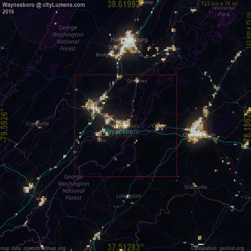

Analysis of Waynesboro night lights 2016
Square area 10x10 km:
 2.44%
2.44%90-99
3.41%80-89
4.55%70-79
5.03%60-69
4.87%50-59
5.52%40-49
2.11%30-39
6.49%20-29
5.03%10-19
29.06%0-9
31.49%Square area 50x50 km:
0.32%90-99
0.4%80-89
0.79%70-79
0.95%60-69
0.91%50-59
1.2%40-49
0.77%30-39
1.12%20-29
1.24%10-19
6.33%0-9
85.96%Clear (daylight) street map image can be seen on geolist.org.
Map coordinates:
38° 37' 11.7" North, 79° 35' 33.4" West
38° 4' 6.5" North, 78° 53' 22.1" West
37° 30' 46.2" North, 78° 11' 10.9" West
Some cities around Waynesboro sort by population:
• Harrisonburg
42.4 km =26.3 mi,  2°
2°
• Charlottesville
36.4 km =22.6 mi,  96°
96°
• Staunton
18.4 km =11.4 mi,  299°
299°
• Stuarts Draft
13.3 km =8.3 mi,  251°
251°
• Hollymead
39.6 km =24.6 mi,  82°
82°
• Fishersville
7.8 km =4.8 mi, 295°
• Bridgewater
35.7 km =22.2 mi,  347°
347°
• Crozet
16.5 km =10.3 mi,  89°
89°
4792522 (p: 21,491)
Sources (retrieved 2019-11-25):
» Earth at Night: Flat Maps 2012, 2016