Bridgewater night lights from space
Night Light of Bridgewater (Virginia) from space (United States) Src. Average luminocity for 10x10km area is 19.2211% and for 50x50km: 6.1895%.
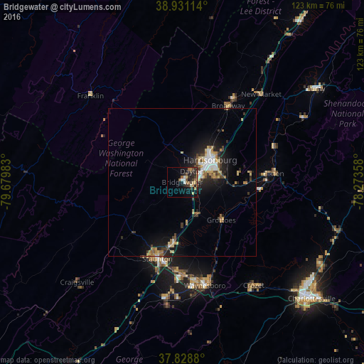
Analysis of Bridgewater night lights 2016
Square area 10x10 km:
 1.36%
1.36%90-99
2.04%80-89
2.72%70-79
2.72%60-69
2.72%50-59
2.72%40-49
2.55%30-39
4.42%20-29
9.01%10-19
13.61%0-9
56.12%Square area 50x50 km:
0.67%90-99
0.81%80-89
1.06%70-79
0.67%60-69
0.83%50-59
0.72%40-49
0.7%30-39
1.03%20-29
1.83%10-19
4.55%0-9
87.12%Clear (daylight) street map image can be seen on geolist.org.
Map coordinates:
38° 55' 52.1" North, 79° 40' 47.4" West
38° 22' 55.5" North, 78° 58' 36.1" West
37° 49' 43.7" North, 78° 16' 24.9" West
Some cities around Bridgewater sort by population:
• Harrisonburg
12 km =7.5 mi,  51°
51°
• Charlottesville
58.7 km =36.5 mi,  131°
131°
• Staunton
27.2 km =16.9 mi,  198°
198°
• Waynesboro
35.7 km =22.2 mi,  167°
167°
• Stuarts Draft
39.4 km =24.5 mi,  187°
187°
• Hollymead
55.2 km =34.3 mi,  122°
122°
• Fishersville
31.5 km =19.6 mi,  178°
178°
• Crozet
42.3 km =26.3 mi,  145°
145°
4748925 (p: 5,889)
Sources (retrieved 2019-11-25):
» Earth at Night: Flat Maps 2012, 2016