Murrells Inlet night lights from space
Night Light of Murrells Inlet (South Carolina) from space (United States) Src. Average luminocity for 10x10km area is 44.3974% and for 50x50km: 17.7285%.
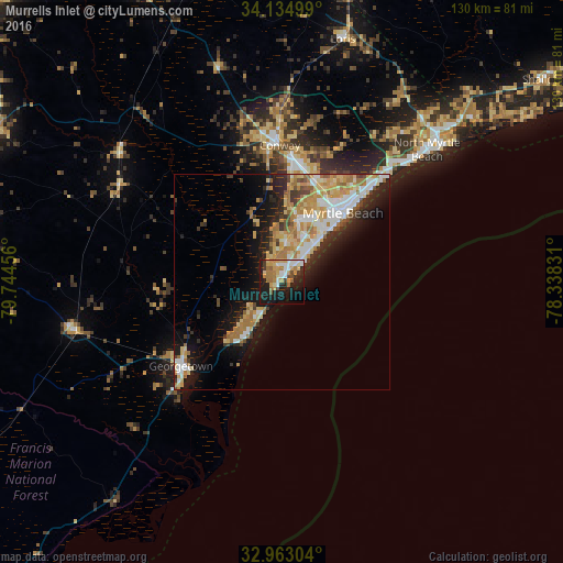
Analysis of Murrells Inlet night lights 2016
Square area 10x10 km:
 5.68%
5.68%90-99
8.61%80-89
5.68%70-79
8.61%60-69
10.99%50-59
2.75%40-49
3.11%30-39
3.3%20-29
11.9%10-19
30.59%0-9
8.79%Square area 50x50 km:
2.75%90-99
3.11%80-89
3.11%70-79
3.03%60-69
3.72%50-59
1.06%40-49
1.29%30-39
1.91%20-29
3.79%10-19
9.27%0-9
66.97%Clear (daylight) street map image can be seen on geolist.org.
Map coordinates:
34° 8' 6" North, 79° 44' 40.4" West
33° 33' 3.6" North, 79° 2' 29.1" West
32° 57' 46.9" North, 78° 20' 17.9" West
Some cities around Murrells Inlet sort by population:
• Myrtle Beach
21 km =13 mi,  43°
43°
• Conway
31.7 km =19.7 mi,  358°
358°
• Socastee
15.3 km =9.5 mi,  15°
15°
• North Myrtle Beach
44.6 km =27.7 mi,  48°
48°
• Red Hill
53.8 km =33.4 mi,  338°
338°
• Garden City
5.6 km =3.5 mi,  33°
33°
• Georgetown
30.4 km =18.9 mi,  230°
230°
• Little River
53.3 km =33.1 mi, 47°
4588682 (p: 7,547)
Sources (retrieved 2019-11-25):
» Earth at Night: Flat Maps 2012, 2016