Batesville night lights from space
Night Light of Batesville (Indiana) from space (United States) Src. Average luminocity for 10x10km area is 20.0629% and for 50x50km: 3.6306%.
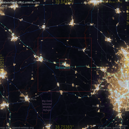
Analysis of Batesville night lights 2016
Square area 10x10 km:
 2.04%
2.04%90-99
2.89%80-89
2.55%70-79
4.76%60-69
2.04%50-59
2.72%40-49
2.04%30-39
2.04%20-29
1.19%10-19
13.27%0-9
64.46%Square area 50x50 km:
0.35%90-99
0.59%80-89
0.52%70-79
0.5%60-69
0.37%50-59
0.49%40-49
0.31%30-39
0.57%20-29
0.63%10-19
1.9%0-9
93.75%Clear (daylight) street map image can be seen on geolist.org.
Map coordinates:
39° 50' 31.3" North, 85° 55' 31.1" West
39° 18' 0.2" North, 85° 13' 19.8" West
38° 45' 13.8" North, 84° 31' 8.6" West
Some cities around Batesville sort by population:
• Oxford
47 km =29.2 mi,  60°
60°
• Connersville
38.6 km =24 mi,  10°
10°
• Greensburg
22.9 km =14.2 mi,  280°
280°
• Harrison
34.9 km =21.7 mi,  96°
96°
• North Vernon
47.6 km =29.6 mi,  226°
226°
• Rushville
39.4 km =24.5 mi,  330°
330°
• Bright
32.8 km =20.4 mi,  106°
106°
• Hidden Valley
36.1 km =22.4 mi,  115°
115°
4254185 (p: 6,611)
Sources (retrieved 2019-11-25):
» Earth at Night: Flat Maps 2012, 2016