Columbus night lights from space
Night Light of Columbus (Indiana) from space (United States) Src. Average luminocity for 10x10km area is 57.4399% and for 50x50km: 7.3052%.

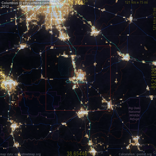
Analysis of Columbus night lights 2016
Square area 10x10 km:
 10.23%
90-99
14.45%80-89
5.68%70-79
8.93%60-69
8.6%50-59
9.09%40-49
6.17%30-39
6.17%20-29
20.45%10-19
10.23%0-9
0%Square area 50x50 km:
0.65%90-99
0.97%80-89
0.87%70-79
0.86%60-69
1.08%50-59
1.12%40-49
1.12%30-39
1.06%20-29
1.95%10-19
6.74%0-9
83.58%Clear (daylight) street map image can be seen on geolist.org.
Map coordinates:
39° 44' 39.1" North, 86° 37' 28.2" West
39° 12' 5.2" North, 85° 55' 17" West
38° 39' 16.1" North, 85° 13' 5.7" West
Some cities around Columbus sort by population:
• Greenwood
48.5 km =30.1 mi,  340°
340°
• Franklin
33.1 km =20.6 mi, 339°
• Seymour
27.1 km =16.8 mi,  174°
174°
• Shelbyville
37.7 km =23.4 mi,  19°
19°
• Greensburg
40.6 km =25.2 mi,  68°
68°
• Bargersville
41.4 km =25.7 mi,  329°
329°
• North Vernon
33.6 km =20.9 mi,  130°
130°
• New Whiteland
42.4 km =26.3 mi, 339°
4256038 (p: 46,690)
Sources (retrieved 2019-11-25):
» Earth at Night: Flat Maps 2012, 2016