Seymour night lights from space
Night Light of Seymour (Indiana) from space (United States) Src. Average luminocity for 10x10km area is 37.4351% and for 50x50km: 5.6621%.
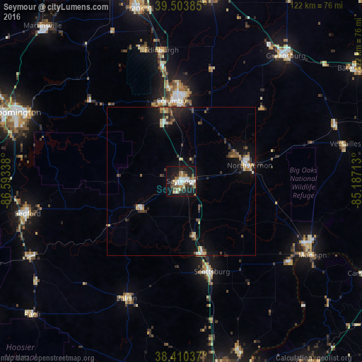
Analysis of Seymour night lights 2016
Square area 10x10 km:
 7.47%
7.47%90-99
7.14%80-89
3.57%70-79
2.6%60-69
4.87%50-59
6.17%40-49
6.01%30-39
3.25%20-29
5.19%10-19
40.42%0-9
13.31%Square area 50x50 km:
0.55%90-99
0.8%80-89
0.66%70-79
0.5%60-69
0.61%50-59
0.9%40-49
0.82%30-39
0.97%20-29
1.36%10-19
5.42%0-9
87.41%Clear (daylight) street map image can be seen on geolist.org.
Map coordinates:
39° 30' 13.9" North, 86° 35' 36.2" West
38° 57' 33.2" North, 85° 53' 24.9" West
38° 24' 37.3" North, 85° 11' 13.7" West
Some cities around Seymour sort by population:
• Columbus
27.1 km =16.8 mi,  354°
354°
• Bedford
52.8 km =32.8 mi,  258°
258°
• North Madison
47.7 km =29.6 mi,  116°
116°
• Madison
50.7 km =31.5 mi, 119°
• Greensburg
54.7 km =34 mi,  39°
39°
• Scottsburg
32.1 km =19.9 mi,  161°
161°
• North Vernon
23.6 km =14.7 mi,  77°
77°
• Salem
43.4 km =27 mi,  204°
204°
4264617 (p: 19,478)
Sources (retrieved 2019-11-25):
» Earth at Night: Flat Maps 2012, 2016