Bargersville night lights from space
Night Light of Bargersville (Indiana) from space (United States) Src. Average luminocity for 10x10km area is 24.3149% and for 50x50km: 28.371%.
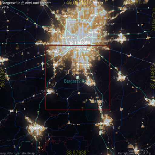
Analysis of Bargersville night lights 2016
Square area 10x10 km:
 0%
0%90-99
1.3%80-89
2.44%70-79
2.76%60-69
4.87%50-59
5.19%40-49
4.22%30-39
7.14%20-29
16.4%10-19
23.38%0-9
32.31%Square area 50x50 km:
5.1%90-99
5.79%80-89
3.86%70-79
4.66%60-69
4.31%50-59
3.59%40-49
3.27%30-39
3.56%20-29
5.39%10-19
9.46%0-9
51.01%Clear (daylight) street map image can be seen on geolist.org.
Map coordinates:
40° 3' 40.1" North, 86° 52' 15.2" West
39° 31' 15.2" North, 86° 10' 4" West
38° 58' 35" North, 85° 27' 52.7" West
Some cities around Bargersville sort by population:
• Indianapolis
27.5 km =17.1 mi,  1°
1°
• Greenwood
11.6 km =7.2 mi,  26°
26°
• Plainfield
28.4 km =17.6 mi,  315°
315°
• Franklin
10.7 km =6.6 mi,  114°
114°
• Beech Grove
23.3 km =14.5 mi,  16°
16°
• Martinsville
24.6 km =15.3 mi,  245°
245°
• Mooresville
20.4 km =12.7 mi,  300°
300°
• New Whiteland
7.5 km =4.7 mi,  56°
56°
4254124 (p: 6,846)
Sources (retrieved 2019-11-25):
» Earth at Night: Flat Maps 2012, 2016