Colleyville night lights from space
Night Light of Colleyville (Texas) from space (United States) Src. Average luminocity for 10x10km area is 91.5073% and for 50x50km: 82.8528%.
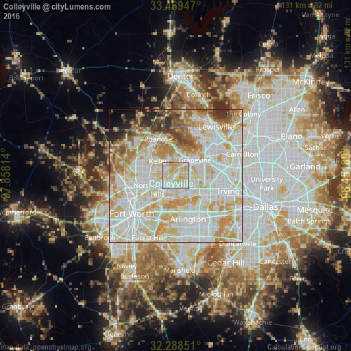
Analysis of Colleyville night lights 2016
Square area 10x10 km:
 27.66%
90-99
29.3%80-89
32.42%70-79
10.62%60-69
0%50-59
0%40-49
0%30-39
0%20-29
0%10-19
0%0-9
0%Square area 50x50 km:
27.96%90-99
26.5%80-89
13.77%70-79
10.87%60-69
6.78%50-59
3.94%40-49
2.7%30-39
2.56%20-29
2.15%10-19
1.56%0-9
1.21%Clear (daylight) street map image can be seen on geolist.org.
Map coordinates:
33° 28' 10.1" North, 97° 51' 29.3" West
32° 52' 51.5" North, 97° 9' 18" West
32° 17' 18.6" North, 96° 27' 6.8" West
Some cities around Colleyville sort by population:
• North Richland Hills
8.6 km =5.3 mi,  233°
233°
• Euless
8.4 km =5.2 mi,  125°
125°
• Grapevine
9.3 km =5.8 mi,  50°
50°
• Bedford
4.3 km =2.7 mi,  164°
164°
• Hurst
6.6 km =4.1 mi,  192°
192°
• Southlake
7 km =4.3 mi,  16°
16°
• Watauga
9.7 km =6 mi,  254°
254°
• Richland Hills
9.9 km =6.2 mi,  223°
223°
4682478 (p: 25,487)
Sources (retrieved 2019-11-25):
» Earth at Night: Flat Maps 2012, 2016