Collinsville night lights from space
Night Light of Collinsville (Oklahoma) from space (United States) Src. Average luminocity for 10x10km area is 35.0332% and for 50x50km: 21.7114%.
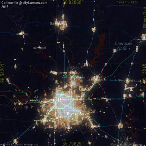
Analysis of Collinsville night lights 2016
Square area 10x10 km:
 0.35%
0.35%90-99
1.92%80-89
3.5%70-79
3.85%60-69
6.12%50-59
12.94%40-49
12.94%30-39
11.36%20-29
10.66%10-19
22.55%0-9
13.81%Square area 50x50 km:
3.69%90-99
3.48%80-89
2.63%70-79
2.22%60-69
3.23%50-59
4.03%40-49
3.63%30-39
5.26%20-29
4.05%10-19
8.73%0-9
59.05%Clear (daylight) street map image can be seen on geolist.org.
Map coordinates:
36° 55' 43.2" North, 96° 32' 31.2" West
36° 21' 52.3" North, 95° 50' 20" West
35° 47' 46.6" North, 95° 8' 8.7" West
Some cities around Collinsville sort by population:
• Tulsa
27.2 km =16.9 mi,  210°
210°
• Broken Arrow
35 km =21.7 mi,  172°
172°
• Owasso
10.7 km =6.6 mi,  187°
187°
• Jenks
39.7 km =24.7 mi,  197°
197°
• Sand Springs
34.8 km =21.6 mi,  224°
224°
• Claremore
20.8 km =12.9 mi,  106°
106°
• Skiatook
14.6 km =9.1 mi,  271°
271°
• Catoosa
21.2 km =13.2 mi,  156°
156°
4533909 (p: 6,492)
Sources (retrieved 2019-11-25):
» Earth at Night: Flat Maps 2012, 2016