Clarksville night lights from space
Night Light of Clarksville (Arkansas) from space (United States) Src. Average luminocity for 10x10km area is 38.2766% and for 50x50km: 3.6589%.
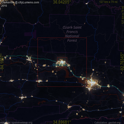
Analysis of Clarksville night lights 2016
Square area 10x10 km:
 4.58%
4.58%90-99
7.51%80-89
5.68%70-79
2.38%60-69
8.06%50-59
6.96%40-49
2.56%30-39
4.95%20-29
7.33%10-19
41.39%0-9
8.61%Square area 50x50 km:
0.21%90-99
0.45%80-89
0.49%70-79
0.33%60-69
0.59%50-59
0.69%40-49
0.35%30-39
0.86%20-29
0.62%10-19
3.09%0-9
92.32%Clear (daylight) street map image can be seen on geolist.org.
Map coordinates:
36° 2' 31.4" North, 94° 10' 10.9" West
35° 28' 17.3" North, 93° 27' 59.7" West
34° 53' 48.5" North, 92° 45' 48.4" West
Some cities around Clarksville sort by population:
• Fort Smith
85 km =52.8 mi,  263°
263°
• Fayetteville
90.6 km =56.3 mi,  316°
316°
• Russellville
37 km =23 mi,  125°
125°
• Van Buren
80 km =49.7 mi,  267°
267°
• Harrison
90.3 km =56.1 mi,  20°
20°
• Greenwood
77 km =47.8 mi,  248°
248°
• Morrilton
74.6 km =46.4 mi,  118°
118°
• Alma
68.4 km =42.5 mi, 270°
4105879 (p: 9,433)
Sources (retrieved 2019-11-25):
» Earth at Night: Flat Maps 2012, 2016