Alma night lights from space
Night Light of Alma (Arkansas) from space (United States) Src. Average luminocity for 10x10km area is 22.4194% and for 50x50km: 12.2113%.
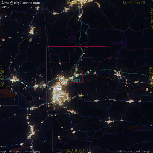
Analysis of Alma night lights 2016
Square area 10x10 km:
 0.73%
0.73%90-99
2.93%80-89
2.38%70-79
2.75%60-69
2.38%50-59
5.31%40-49
2.56%30-39
6.78%20-29
4.58%10-19
30.77%0-9
38.83%Square area 50x50 km:
1.54%90-99
2.07%80-89
1.78%70-79
1.5%60-69
1.77%50-59
2.14%40-49
1.27%30-39
2.39%20-29
3.21%10-19
7.02%0-9
75.32%Clear (daylight) street map image can be seen on geolist.org.
Map coordinates:
36° 2' 54.3" North, 94° 55' 30" West
35° 28' 40.3" North, 94° 13' 18.8" West
34° 54' 11.7" North, 93° 31' 7.5" West
Some cities around Alma sort by population:
• Fort Smith
19 km =11.8 mi,  237°
237°
• Fayetteville
65.3 km =40.6 mi,  5°
5°
• Van Buren
12.3 km =7.6 mi,  248°
248°
• Greenwood
29.3 km =18.2 mi,  186°
186°
• Poteau
59.6 km =37 mi,  217°
217°
• Sallisaw
51.3 km =31.9 mi,  267°
267°
• Farmington
62.8 km =39 mi,  357°
357°
• Prairie Grove
56 km =34.8 mi,  351°
351°
4099296 (p: 5,575)
Sources (retrieved 2019-11-25):
» Earth at Night: Flat Maps 2012, 2016