Clarendon Hills night lights from space
Night Light of Clarendon Hills (Illinois) from space (United States) Src. Average luminocity for 10x10km area is 92.5617% and for 50x50km: 89.4176%.
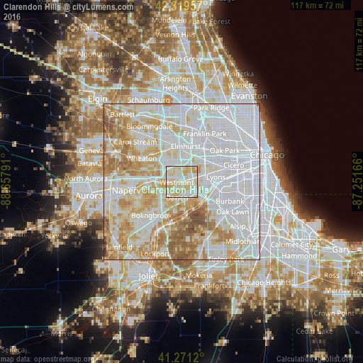
Analysis of Clarendon Hills night lights 2016
Square area 10x10 km:
 27.92%
90-99
34.42%80-89
31.66%70-79
6.01%60-69
0%50-59
0%40-49
0%30-39
0%20-29
0%10-19
0%0-9
0%Square area 50x50 km:
40.84%90-99
22.51%80-89
13%70-79
10.38%60-69
8.46%50-59
3.85%40-49
0.84%30-39
0.12%20-29
0%10-19
0%0-9
0%Clear (daylight) street map image can be seen on geolist.org.
Map coordinates:
42° 19' 10.5" North, 88° 39' 28.5" West
41° 47' 51.1" North, 87° 57' 17.2" West
41° 16' 16.3" North, 87° 15' 6" West
Some cities around Clarendon Hills sort by population:
• Downers Grove
4.8 km =3 mi,  285°
285°
• Westmont
1.7 km =1.1 mi,  263°
263°
• Darien
5.3 km =3.3 mi,  197°
197°
• Hinsdale
1.5 km =0.9 mi,  75°
75°
• Western Springs
4.7 km =2.9 mi,  73°
73°
• Burr Ridge
6.2 km =3.9 mi,  150°
150°
• Willowbrook
3.5 km =2.2 mi, 153°
• Oak Brook
4.5 km =2.8 mi,  28°
28°
4888080 (p: 8,676)
Sources (retrieved 2019-11-25):
» Earth at Night: Flat Maps 2012, 2016