Burr Ridge night lights from space
Night Light of Burr Ridge (Illinois) from space (United States) Src. Average luminocity for 10x10km area is 84.2873% and for 50x50km: 89.3586%.
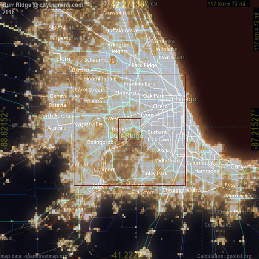
Analysis of Burr Ridge night lights 2016
Square area 10x10 km:
 24.03%
90-99
20.78%80-89
19.48%70-79
14.29%60-69
12.01%50-59
8.44%40-49
0.97%30-39
0%20-29
0%10-19
0%0-9
0%Square area 50x50 km:
41%90-99
21.68%80-89
13.05%70-79
11.21%60-69
8.31%50-59
4.03%40-49
0.69%30-39
0.03%20-29
0%10-19
0%0-9
0%Clear (daylight) street map image can be seen on geolist.org.
Map coordinates:
42° 16' 16.9" North, 88° 37' 17.5" West
41° 44' 56.1" North, 87° 55' 6.2" West
41° 13' 19.9" North, 87° 12' 55" West
Some cities around Burr Ridge sort by population:
• Darien
4.6 km =2.9 mi,  274°
274°
• Hinsdale
6 km =3.7 mi,  345°
345°
• Western Springs
6.9 km =4.3 mi,  12°
12°
• Justice
6.7 km =4.2 mi,  94°
94°
• Clarendon Hills
6.2 km =3.9 mi,  330°
330°
• Willowbrook
2.7 km =1.7 mi, 327°
• Countryside
5 km =3.1 mi,  41°
41°
• Willow Springs
4.9 km =3 mi,  100°
100°
4886090 (p: 10,818)
Sources (retrieved 2019-11-25):
» Earth at Night: Flat Maps 2012, 2016