Hinsdale night lights from space
Night Light of Hinsdale (Illinois) from space (United States) Src. Average luminocity for 10x10km area is 92.1867% and for 50x50km: 89.9995%.
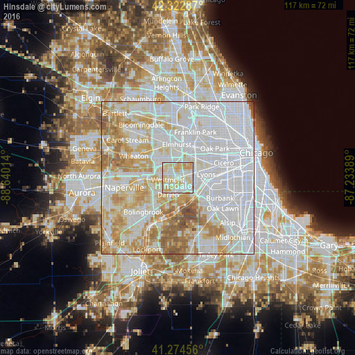
Analysis of Hinsdale night lights 2016
Square area 10x10 km:
 27.11%
90-99
33.12%80-89
32.31%70-79
7.47%60-69
0%50-59
0%40-49
0%30-39
0%20-29
0%10-19
0%0-9
0%Square area 50x50 km:
42.69%90-99
22.38%80-89
12.66%70-79
10.01%60-69
7.83%50-59
3.63%40-49
0.75%30-39
0.05%20-29
0%10-19
0%0-9
0%Clear (daylight) street map image can be seen on geolist.org.
Map coordinates:
42° 19' 22.3" North, 88° 38' 24.5" West
41° 48' 3.1" North, 87° 56' 13.2" West
41° 16' 28.4" North, 87° 14' 2" West
Some cities around Hinsdale sort by population:
• Westmont
3.2 km =2 mi,  260°
260°
• La Grange
5.6 km =3.5 mi,  85°
85°
• Western Springs
3.2 km =2 mi,  71°
71°
• Burr Ridge
6 km =3.7 mi,  165°
165°
• Clarendon Hills
1.5 km =0.9 mi, 255°
• Willowbrook
3.5 km =2.2 mi,  178°
178°
• Oak Brook
3.6 km =2.2 mi,  10°
10°
• Countryside
5.3 km =3.3 mi,  112°
112°
4896012 (p: 17,628)
Sources (retrieved 2019-11-25):
» Earth at Night: Flat Maps 2012, 2016