Childersburg night lights from space
Night Light of Childersburg (Alabama) from space (United States) Src. Average luminocity for 10x10km area is 23.0892% and for 50x50km: 10.5787%.
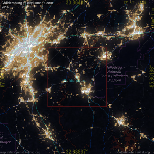
Analysis of Childersburg night lights 2016
Square area 10x10 km:
 1.4%
1.4%90-99
2.1%80-89
1.92%70-79
2.8%60-69
2.45%50-59
4.37%40-49
5.07%30-39
4.2%20-29
6.82%10-19
36.01%0-9
32.87%Square area 50x50 km:
0.72%90-99
0.83%80-89
1.22%70-79
1.17%60-69
1.58%50-59
1.12%40-49
2.01%30-39
3.55%20-29
3.35%10-19
8.65%0-9
75.8%Clear (daylight) street map image can be seen on geolist.org.
Map coordinates:
33° 51' 50.4" North, 87° 3' 29.2" West
33° 16' 41.4" North, 86° 21' 17.9" West
32° 41' 18.1" North, 85° 39' 6.7" West
Some cities around Childersburg sort by population:
• Talladega
29 km =18 mi,  52°
52°
• Pell City
34.8 km =21.6 mi,  10°
10°
• Sylacauga
15.1 km =9.4 mi,  140°
140°
• Chelsea
26.5 km =16.5 mi,  285°
285°
• Leeds
34.8 km =21.6 mi,  329°
329°
• Meadowbrook
34.6 km =21.5 mi, 293°
• Lake Purdy
34.6 km =21.5 mi,  299°
299°
• Brook Highland
34.4 km =21.4 mi, 300°
4055045 (p: 5,046)
Sources (retrieved 2019-11-25):
» Earth at Night: Flat Maps 2012, 2016