Cherry Valley night lights from space
Night Light of Cherry Valley (California) from space (United States) Src. Average luminocity for 10x10km area is 39.3759% and for 50x50km: 22.0377%.
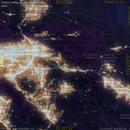
Analysis of Cherry Valley night lights 2016
Square area 10x10 km:
 0.87%
0.87%90-99
1.4%80-89
1.4%70-79
5.77%60-69
13.64%50-59
12.41%40-49
14.51%30-39
6.64%20-29
17.83%10-19
16.61%0-9
8.92%Square area 50x50 km:
2.43%90-99
3.01%80-89
1.57%70-79
2.74%60-69
5.28%50-59
4.66%40-49
4.75%30-39
3.72%20-29
5.93%10-19
11.8%0-9
54.12%Clear (daylight) street map image can be seen on geolist.org.
Map coordinates:
34° 33' 13" North, 117° 40' 49.4" West
33° 58' 21.1" North, 116° 58' 38.1" West
33° 23' 14.7" North, 116° 16' 26.9" West
Some cities around Cherry Valley sort by population:
• Moreno Valley
23.7 km =14.7 mi,  260°
260°
• Redlands
21.1 km =13.1 mi,  296°
296°
• Yucaipa
9.1 km =5.7 mi,  318°
318°
• San Jacinto
21 km =13 mi,  175°
175°
• Beaumont
4.8 km =3 mi, 180°
• Banning
10.7 km =6.6 mi,  119°
119°
• Mentone
18.1 km =11.2 mi,  306°
306°
• Calimesa
8.6 km =5.3 mi,  294°
294°
5336185 (p: 6,362)
Sources (retrieved 2019-11-25):
» Earth at Night: Flat Maps 2012, 2016